Overview
NEU4BRIX is a machine-learning processor that turns airborne P-band polarimetric SAR data into maps of forest Above Ground Biomass (AGB) at 2 m resolution. It was developed by CNR-IFAC (Institute of Applied Physics “Nello Carrara”, Florence) for the European Space Agency, within the Biomass Retrieval Intercomparison Exercise (BRIX I and II) and its NEU4BRIX follow-on.
The processor uses AfriSAR campaign data over four sites in Gabon: Lopé National Park, Mondah, Mabounié and Rabi. It supports the preparation of the ESA BIOMASS mission, the first spaceborne P-band SAR. The technical note, the user manual and the full Python code are released here for reuse and comparison.
Method
Two machine-learning algorithms, an Artificial Neural Network and a Random Forest, estimate AGB from P-band backscatter (HH, HV, VH, VV), local incidence angle and an auxiliary lidar tree-height map. They are trained and validated against in-situ AGB on the BRIX 1-ha plots. Full validation results are given in the Technical Note.
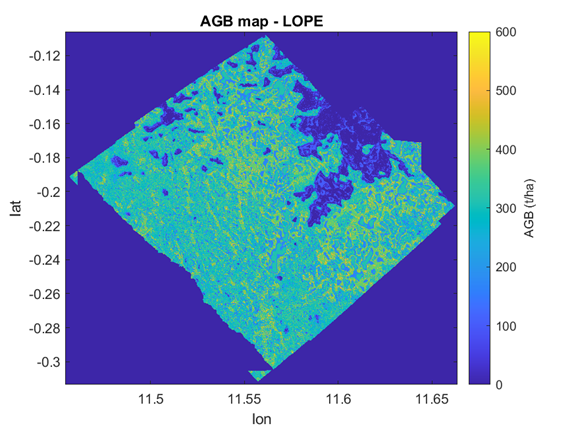
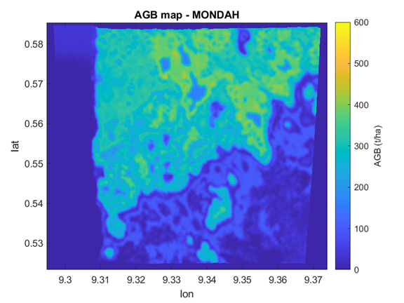
AGB maps (t/ha) at 2 m resolution produced by the Random Forest algorithm for Lopé (top) and Mondah (bottom).
Downloads
| Item | Content | Link |
| Technical Note (NEU4BRIX_TN_V01) | Scientific background, datasets, algorithm design, validation and AGB maps | [LINK TO REPORT] |
| User Manual (NEU4BRIX_User_Manual_v01) | Installation, configuration options, inputs/outputs, how to run training, testing and validation | [LINK TO MANUAL] |
| Processor package (IFAC_NEU4BRIX.zip, about 4.6 GB) | Python code, pretrained ANN and RF models, coregistered AfriSAR input images for the four sites, ROI shapefiles, training file, package list | [LINK TO CODE] |
Using the code
Unzip the package and run BIOMASS_ANN_RF.py. Flags at the top of the script select training, testing (map generation) and the ML method (ANN or RF); paths and parameters are set in the same block. Requirements and step-by-step instructions are in the User Manual.
Licence: Technical Note and User Manual are released under Creative Commons Attribution 4.0 (CC BY 4.0); the code under the MIT License. Free use and modification are allowed, provided the source is credited.
How to cite: Santi, E. et al. (2020). Machine-Learning Applications for the Retrieval of Forest Biomass from Airborne P-Band SAR Data. Remote Sensing, 12, 804. doi:10.3390/rs12050804
Contact: Emanuele Santi, CNR-IFAC, Microwave Remote Sensing Methods group — e.santi@ifac.cnr.it
Using NEU4BRIX? We would be glad to hear from you. A short email with your name, affiliation and application helps us track the impact of the work and keep users informed of updates.
Acknowledgement: This work was funded by the European Space Agency in the framework of NEU4BRIX activity. AfriSAR data were provided by ESA within BRIX-II programme.